GEOG 1700 - NATURAL DISASTERS
Instructor: Sally Timmins
PART I: TRACKING EARTHQUAKES
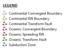
OCEANIC-OCEANIC PLATE BOUNDARY

|

|

- MAGNITUDE: 4.4
- LOCATION: PUERTO RICO REGION
- COORDINATES: (Longitude: 19.0988, Latitude: -65.3515)
- DATE: Oct. 2, 2013 Wednesday
- TIME: 15:26:35 UTC; 11:26:35 AM at epicenter
- DEPTH: 13 km (8.08 mi)
- Oceanic-to-Oceanic
- The Puerto Rico Trench is based at a boundary in between two plates (Caribbean Plate moving east and North American plate moving west) passing each other by a Oceanic Transform Fault fairly close to a Subduction Zone
OCEANIC-CONTINENTAL

|

|

- MAGNITUDE: 4.3
- LOCATION: ALEUTIAN ISLANDS, ALASKA
- COORDINATES: 169°41'52.86"W, 52°26'56.13"N
- DATE: Oct. 9, 2013 Wednesday
- TIME: 19:49:00 UTC; 11:49:00 AM at epicenter
- DEPTH: 30 km (18.64 mi)
CONTINENTAL-CONTINENTAL

|

|
- MAGNITUDE: 4.0
- LOCATION: CENTRAL ALASKA
- COORDINATES: 150°32'37.95"W, 62°54'20.90"N
- DATE: Oct. 6, 2013 Sunday
- TIME: 13:42:17 UTC; 05:42:17 AM at epicenter
- DEPTH: 104.70 km (65.06 mi)
TRANSFORM PLATE BOUNDARY

|

|

- MAGNITUDE: 4.3
- LOCATION: SOUTHERN CALIFORNIA, UNITED STATES
- COORDINATES: 116°17'40.44"W, 34°42'36.39"N
- DATE: Oct. 2, 2013 Wednesday
- TIME: 15:26:35 UTC; 11:26:35 AM at epicenter
- DEPTH: 1.9 km (1.18 mi)
DIVERGENT PLATE BOUNDARY

|

- MAGNITUDE: 6.0
- LOCATION: OFFSHORE SUCRE, VENEZUELA
- COORDINATES: 62°11'28.82"W, 10°45'42.28"N
- DATE: Oct. 12, 2013 Saturday
- TIME: 02:10:28 UTC; 02:10:28 AM at epicenter
- DEPTH: 60.90 km (37.84 mi)
PART ii: IDENTIFYING VOLCANOES
CINDER CONE

|

|
- VOLCANO NAME: Kostakan
- LOCATION: Kamchatka Peninsula (Russia)
- OCCURS ON WHAT PLATE BOUNDARY: Convergent Plate Boundary - Australian Plate to Eurasian Plate
SHIELD VOLCANO

|

|
- VOLCANO NAME: Fukue-jima
- LOCATION: Kyushu (Japan)
- OCCURS ON WHAT PLATE BOUNDARY: Ring of Fire
CALDERA

|

|
- VOLCANO NAME: Gedamsa Caldera
- LOCATION: Ethiopia
- OCCURS ON WHAT PLATE BOUNDARY: Divergent Plate Boundary - African Plate
STRATOVOLCANO/COMPOSITE VOLCANO

|

|
- VOLCANO NAME: Snaefellsjökull
- LOCATION: Western Iceland
- OCCURS ON WHAT PLATE BOUNDARY: Divergent Plate Boundary - N American Plate & Eurasian Plate
PART III: ASSIGNMENT REFLECTION
- As you are well aware, satellite imagery and aerial photography are freely available for almost the entire world thanks to Internet programs like Google Earth. Should citizens become better at interpreting their world from an aerial viewpoint and what ethical and civil liberty issues might or should concern citizens about this technology?
I believe we all need our own privacy issues, but I admire the fact Google Earth allows you to practically stream the world from your own computer. If you could stream things "live" then that's another problem. To operate a drone you would need to be licensed and also having insurance for that drone. If you were caught doing something not authorized or certified, you can be fined.
- Reflect on how you thought about earthquakes in Utah before you started this assignment and how you think about it now that the course is over. Have any of your assumptions or understandings changed? Why?
Basically, Utah or anywhere on this planet is not safe. There are a lot of factors to consider with earthquakes, the depth of the focus, and the magnitude. Including the geological location of the earthquake, for example, the material amplification and whatever else can be triggered after an earthquake.
